Jump to navigation

Picture This:
California Perspectives on American History
  • Home
  • Browse Pictures
  • Picture Map
  • Log In
  • Activities
  • Teaching Resources
  • About the Website

Search form

Early California: pre-1769–1840s: Early Explorers

Click image to zoom in.
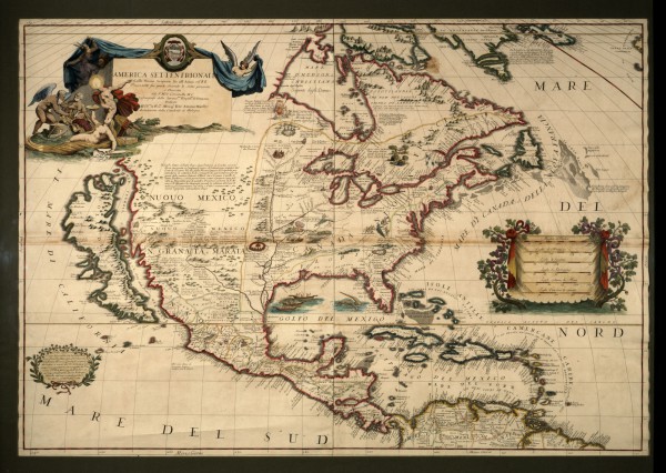
Or view larger version.
America Setentrionale – Map of the North America. 1688. P. Mro Coronelli Venice. Map. Collection of Oakland Museum of California.

This map shows California as an island, a long held interpretation based on misinformation about the Gulf of California. The Gulf begins at the southern tip of Baja California and extends 700 miles to the point where the waters of the Colorado River flow into it. The Gulf was long thought to be a strait that separated the mainland of Mexico from the island of California. Francisco Ulloa proved this to be untrue. In 1539, Ulloa sailed from Acapulco up the west coast to the head of the Gulf, discovering Baja California was in fact a peninsula, not an island. However, Spain choose not to share this information with other nations.

  • More information about this Topic
Timeline: Early California: pre-1769–1840s
« previous picture
next picture »

Browse By Timeline

  • Early California: pre-1769–1840s
  • Gold Rush: 1848–1860
  • Early Statehood: 1850 – 1880s
  • Progressive Era: 1890–1920s
  • Depression Era: 1930s
  • World War II Homefront Era: 1940s
  • Homogenization, Protests & Outright Rebellion: 1950s
  • Unforgettable Change: 1960s
  • Cultural Realignment & Economic Recession: 1970s
  • The Reagan Years: 1980s
  • 1990s to Present

Also, browse by Theme or by Most Useful

California.  Many Voices.  Many Stories.  Oakland Museum of California
Picture This is a project of the Oakland Museum of California